|
<< Click to Display Table of Contents >> Eumetsat - CM SAF |
  
|
|
<< Click to Display Table of Contents >> Eumetsat - CM SAF |
  
|
(Go to World satellites spatial and time coverage main page)
EUMETSAT (http://www.eumetsat.int/website/home/Satellites/index.html)
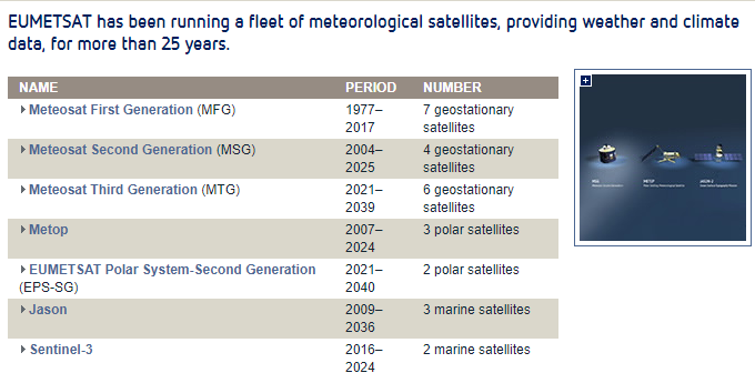
EUMETSAT is the European operational satellite agency. EUMETSAT gathers satellite data on weather, climate and environment around the clock, and delivers them to Member and Cooperating States, international partners, and users world-wide. Within the frame of the World Meteorological Organisation, EUMETSAT cooperates with the United States, sharing and exploiting a joint polar system with the US National Oceanographic and Atmospheric Administration (NOAA), with 2 satellites (Metop/EUMETSAT and NPP Suomi/NOAA) – flying on complementary polar orbits, the so called “mid morning” and “afternoon” orbits. EUMETSAT cooperates also with the Japan Meteorological Agency (JMA) an the China Meteorological Administration (CMA) in the frame of the Sustained and Coordinated Processing of Environmental Satellite Data for Climate Monitoring (SCOPE-CM) - See for instance what is on the way regarding Land surface Albedo (SCM-03 LAGS Sub-project).
Follow the following links for details about EUMETSAT satellites: Meteosat , Metop , EUMETSAT Polar, Jason2.

The Satellite Application Facility on Climate Monitoring (CM-SAF) (http://www.eumetsat.int/website/home/Satellites/GroundSegment/Safs/ClimateMonitoring/index.html)
EUMETSAT climate monitoring activities involve the Central Facilities in Darmstadt and the network of Satellite Application Facilities (SAFs). The CM SAF generates and archives high-quality datasets for specific climate application areas, through the exploitation of satellite measurements with state-of-the-art algorithms, to derive information about the climate variables of the Earth system. CM SAF is also engaged in training customers in the use of CM SAF products. It aims to provide data that can be further used to assess the current climate, e.g. for infrastructure planning; to assess the climate variability and change, including climate change detection and attribution; to support the development of climate models; by validating long-range and short-term climate forecasts; to assess the impact of changing environment, and to provide evidence for policy actions.
Among other data, CM-SAF provides temperature and precipitable water colum height (pw) on a monthly basis, with a (90km2) spatial resolution.
Follow the link for information on the pw calculation method.
The following satellite data sources are used to generate CM SAF data products:
•Meteosat satellites
•Metop satellites
•NOAA satellites