CSV and GeoTIFF Ground data
CSV Ground data
In the near shadings you can click on File > Import > Import ground data (CSV, TIF) in the menu to import a text file containing 3D coordinates of points.
Here is an example of content for the file you can import this way :
0   250.01   0.19
5.55   247.2   0
10.05   269.66   0.29
15.63   267.05   0.09
17.56   246.27   0.82
Each line must contain the coordinates for one point only, in the following order : X Y Z.
The unit is in meters (m), you should make sure that the origin point is near 0 or the generated ground will appear far from the scene origin. Anyway, you will be able to move it where you want in the scene after it has been imported.
You can choose one of the following separators: [TAB] ; , [SPACE]
A ground object will be created as soon as at least three correct and distinct points are found in the file. A triangulation is automatically made in order to physically represent the ground.
Scene details
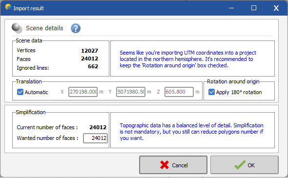
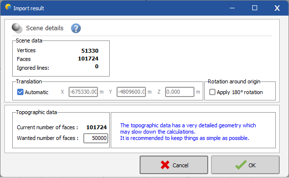
This panel provides a summary of the imported ground object, including the total number of vertices and faces. Additionally, it offers 3 optional operations to be performed on the resulting ground object.
Translation
If the ground distance (measured from its closest point to the origin) exceeds 5 kilometers, the 'Automatic translation' option is enabled, and the X, Y, and Z values for the applied correction are filled in order to move the ground object at the origin of the scene. You can choose to toggle this option as desired and adjust these values based on the translation you intend to apply.
Rotation around the origin
If the import process detects that the input coordinates are provided in UTM format, the 'Apply 180° rotation' option is checked if the project is located in the northern hemisphere. If so, a message is displayed recommending to keep the option checked. However, you have the flexibility to enable this option regardless of whether this condition is met. It is not advised to uncheck it though.
Simplification
This option allows for the simplification of topographic data when the number of polygons resulting from the import exceeds 100,000. This is because overly detailed geometry can slow down calculations. In such cases, a message is displayed recommending reducing this number. The default value suggested is 50,000, but you have the flexibility to choose any value up to the current number of polygons. Even if the import contains fewer than 100,000 faces, you still have the option to reduce the number of polygons.
TIF Ground data
It is also possible to import a tif file (in GeoTIFF format) that contains ground data. This is done through the same menu item File > Import > Import ground data (CSV, TIF) within the shadings scene. You need to change the filter on the bottom right of the file selection window to display tif files:
When importing a GeoTIFF file PVsyst will first convert it into a CSV file and it will import the CSV file as described in the previous section.


